This National Park was declared as such by Law No. 4389 on February 19, 1956. It is located on the northern slope and in the central part of the Central Mountain Range, covering an approximate area of 779 km².
It extends from east to west, from La Ciénaga de Manabao in the province of La Vega to the Nalga de Maco National Park in the upper basin of the Artibonite River. On its northern boundary, the park borders the communities of Mata Grande in the province of Santiago, La Diferencia, Los Ramones, Lomita, and La Cidra in Santiago Rodríguez, while to the south, it adjoins the José del Carmen Ramírez National Park.
The life zones found in this National Park consist of Lower Montane Wet Forest (Bh-MB) and Lower Montane Very Wet Forest in certain areas, the Lower Montane Pluvial Forest can be found, characterized by high humidity and typical species of this life zone such as manacla and tree ferns.
The terrain is steep and shares with the José del Carmen Ramírez National Park the highest point in the Antilles, represented by Pico Duarte, which reaches an elevation of 3,175 meters, followed by the peaks La Pelona (3,097 meters), Yaque (2,760 meters), and La Rusilla (3,038 meters). Together with the José del Carmen Ramírez National Park, this National Park encompasses approximately twelve major rivers in the country, including the upper basins of the Yaque del Norte, Jagua, Bao, Ámina, Guayubín rivers, and all their tributaries.
The average temperature is generally cool, especially during the winter when significant drops are experienced. In December and January, temperatures can fall below 0 °C in the early morning, and “pajones” are covered with frost. The lowest temperatures are recorded in the Valle del Tetero, the Valle de Bao, and Macutico. The Park is situated in an area of high precipitation, with records ranging between 1,000 and 3,500 mm; in certain locations, rainfall may exceed 4,000 mm.
The vegetation formations are primarily composed of conifers, mixed species, and broadleaf trees, with the native pine or cuaba pine (Pinus occidentalis) predominating. Other important tree species include sabina (Juniperus gracilior), almendro (Prunus occidentalis), cigua blanca (Nectandra coriacea), cedar (Cedrela odorata), guárana (Cupania americana), palo de viento (Didymopanax tremulus), and pino de teta (Zanthoxylum spinifex), among others.
The avifauna predominantly inhabits the upper levels, and among the bird species found here, we can mention: cotorra (Amazona ventralis), canario (Carduelis dominicensis), cuervo (Corvus leucognaphalus), the national bird cigüa palmera (Dulus dominicus), papagayo (Priotelius roseigaster), perdiz (Geotrygon montana), cuá (Hyetornis rufigularis), gavilán (Buteo ridwayi), and gavilán (Buteo jamaicensis).
Herpetofauna is not very abundant, featuring the lizard Celestus Marcano and reptiles of the genus Alsophius. Mammals are distributed throughout the park territory, although primarily in the most inaccessible areas; among them are the jutía (Plagiodontia aedium) and the wild pig (Sus scrofa).
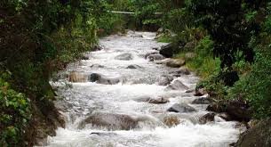
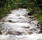
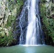
The main ecotourism attraction of the park is the opportunity for hiking in areas of great scenic beauty, amidst extensive natural forests of pine and broadleaf trees. This constitutes an excellent draw for visitors, who have made the routes to Pico Duarte the most significant and well-known destination for ecological tourism in the country. The strong currents of watercourses on the park’s outskirts also offer an excellent opportunity for rafting. Birdwatching holds great potential there, due to both its abundance and diversity.
The most accessible route to reach Armando Bermúdez National Park is through the towns of Manabao and La Ciénaga in La Vega province. Starting from the municipality of Jarabacoa, it takes about 23 kilometers to reach Manabao and around 15 kilometers further to La Ciénaga. Another route is through San José de Las Matas (Santiago province), leading to Mata Grande, which is located on the northern boundary of the park; it is also accessible from Differences, Manacla, and La Leonor in Santiago Rodríguez province.